Saturday, August 10, 2013

August 10, Fiery Gizzard: Raven Point Scouting Trip, Snakes Abound

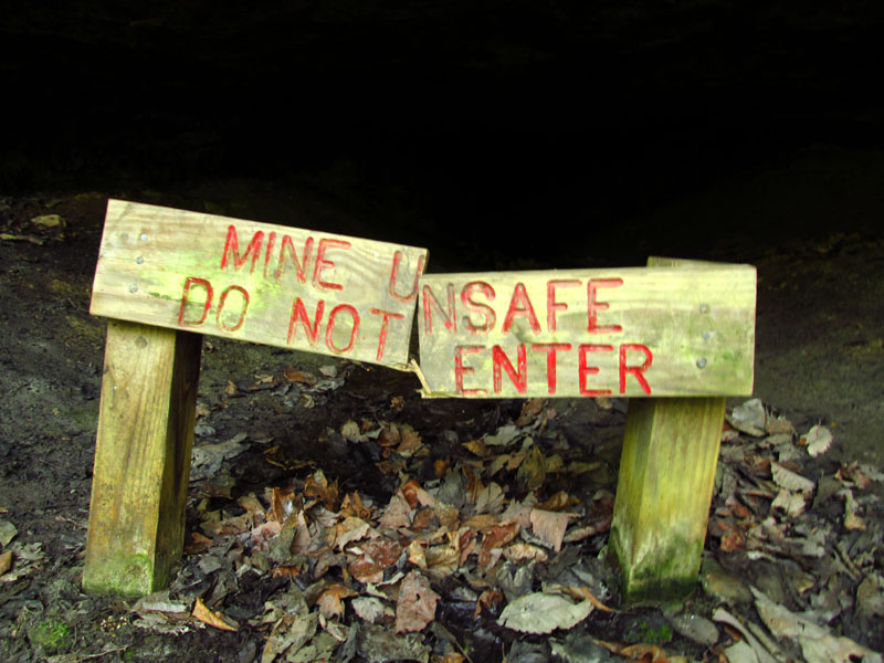
This weekend was a scouting trip of sorts to check out accommodations for an extended group trip later on. Raven Point overlooks Grundy Forest, part of the South Cumberland State Park that we visited earlier in the year for the canoe trip (when I drowned my camera) and then recently returned to for our swim at Sycamore Falls. We had made special arrangements with a property owner that was able to provide us with a place to stay and also access to the trail-head on private property that leads directly to Raven Point. Many hiking and area guide books mention parking at this trail head and walking to nearby Anderson Falls, but as you can see by the signage below this is currently not allowed.


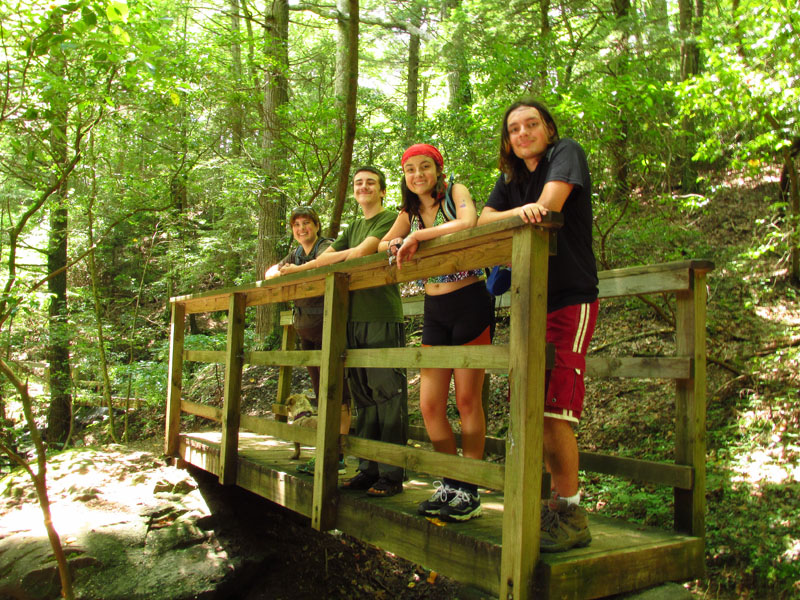
Our host has also constructed a campsite for those folks wishing to break up a long hiking trip along the Fiery Gizzard Trail with a stay overnight in the Adirondack-style shelter built from native poplar.

Facilities included

The shelter with teenager for scale
Anyone wishing to make arrangements with the land owner to either access the falls from the property or to overnight in the shelter can call the number below and ask for Carl. Feel free to tell him Matt and Esther sent you.


Further down the trail is the access point for Anderson falls, a 200+ step staircase that provides an improved route to the canyon floor.


Anderson Falls

The stairs looking up...

...and looking down. 
The state park also maintains a primitive campsite .5 miles from the overlook at the intersection of several trails in a large clearing.

Raven Point Campsite
We walked to the point and enjoyed the view and got a bonus "encounter with nature" moment by way of a 2-foot timber rattler that has taken up residence at the point. In the picture below he was in a crack below the "L" shaped tree at the edge of the cliff. Ben had practically walked over the snake on his way to where he's sitting in the picture. Esther was moving in to get a picture of Ben when she spotted the very active rattler by sheer luck while navigating the crack in the rock. I knew what she had found instantly because she made the universal alert sound for being surprised by legless reptiles in the woods. Actually, it's more of a word than a sound. If you've nearly stepped on a snake, chances are you've said it too.

The rattler popped it's head up to check us out then started rattling his tail and retreated further into the crack. Of the handful of rattlers I've seen in the wild, this was the first that had actually rattled. We retreated and let the snake have the overlook.


Having not slept very well the night before we all headed back to make lunch and relax a little. Ben was plagued with a hacking cough the whole weekend and was a little worn out so he took a nap. (Chan left him a friend to keep watch.)  


After a bite to eat we drove over to the South Cumberland Visitor Center to watch Ranger Park (again, that's his actual name) give a presentation on... snakes! He brought three corn snakes of three different color morphs. The largest is named Ruby and she's extremely patient and relaxed around small kids. 

Chan and Ruby

Timber rattler skin
On our return we hit the trail again. Esther and the kids took it easy near the top of the trail and splashed around in the creek. I headed out further past the point to find a couple of geocaches. It was a couple of hours before sunset and as the temp began to drop, the fog rolled in. Pretty soon the trail looked like this photo in most places. 


Also found some cool mushrooms along the trail.


I found Werner Point and a second overlook where I could look down into the canyon and really see where the fog was coming from. 


Realizing that I had walked about an hour down the trail and that it was about another hour till sunset I quickly returned to met up Esther and the kids to watch the sun go down from Raven Point. The fog rapidly formed to block the sunset and eventually swallow up the point itself, but before it did I managed to get a few pics.


Oh, the rattler was still at the overlook; Esther checked. This time instead of rattling it hissed loudly as a warning. Luckily the snake's home was on the side opposite the setting sun.

More pictures!
Tracklog of my hike, with points of interest marked!


Friday, July 12, 2013

July 12, 2013 - Fiery Gizzard, Sycamore Falls, Stone Door

To prove the fates wrong, we returned Grundy County, Tennessee (where we were when I took my camera for a swim while canoeing) with my new camera! Okay, the trip had little to do with my camera but it kind of worked out that way. Oh, and my camera that was broken... is kind of fixed. I'll talk more about that at the end of the post- because it would be cool for somebody to be able to find the information in a Google search some day.

First item of the day was to stop at the office for South Cumberland State Park so Esther could send some quality time with Park the ranger. That's not a typo. The guy's name is "Park". I'm not making this up. He was our guide for the canoe trip and Esther had mentioned something at that time to him about setting up several days worth of activities for a homeschool group later in the season. Also there was something about "his eyes are shiny like buttons".

While Esther and Park made Big Plans I tortured the kids and they played with my camera. Here is Chan giggling like a (home)school girl. When you say the magic word she giggles. Send $10 to me via PayPal and I'll give you the magic word.  


The kids discovered the "fish eye" effect in the camera. Here, in all it's glory, is a rarity for the blog- a picture of me that is not my backside.

Hello ladies

Chan, riffing on the "fish" in "fish-eye".


After Esther wrapped up her plans to march a herd of homeschool kids into the wilderness and feed them to the wildlife, we drove around to the Fiery Gizzard Trailhead to start our hike down to the falls below. Most of the trail looked like the next few pictures; hill on one side, rushing creek on the other, shaded by breeze-blown trees throughout. Perfect hiking conditions.


Falls at Black Canyon

The Fiery Gizzard Lizard (not a lizard)

We had intended to stop about a half mile down the trail and swim at Blue Hole Falls but when we got there is was occupied (one swimmer, a very large man, was talking on his cell phone while wadding through the water) so we continued on down the trail until reaching Sycamore Falls


Swimming at the falls was incredible. The rock-covered floor of the creek deepens as you approach the actual falls and was well over my head. The pool was free of most debris and there was no leaf liter to contend with. The water was cold, but welcoming after a brief adjustment period (shrinkage!)


I've been behind falls and I've stood under falls but I don't think I've ever been under or behind one that was quite so active. Esther was brave enough to take her camera inside a ziplock bag around to the back of the falls were there was a shelf of very shallow water. The next few pictures are from her blog entry about the same hike.


Ben was the first to retire from swimming, followed by Esther. They both took up residence in the hammocks to recoup their strength. 


Yeah. This happened.

I get this look frequently


While everybody else was resting up I tried to find a nearby geocache. I did not find the cache, but I did find the "Dog Hole" an old coal mine that was dug into and under the canyon wall.


I sat my camera on top of the sign and took a longer exposure to see if I could get an idea of the length of the mine tunnel. I even tried "painting" the darkness with my cellphone flashlight. I still couldn't see very far into the depths of the mine.


Next attempt, I zoomed in on the back of the wall and increased the exposure time to 15 seconds. This is the most I got out of the mine- easily 100 feet of tunnel about four feet high, beyond that, who knows. 


This part of the Dog Hole Trail runs under the canyon cliff wall and the water running off the edge was making for a very believable rainstorm when combined with the strong breeze blowing along side the face of the rocks.


Like I said, I never found the geocache, but according to the hint it's "off the trail under the pile of rocks". The pile of rocks. "Pile" being singular. Here's the hillside near where the GPS was pointing me to search.


But no worries, it was probably one of the best caches that I didn't find. The path to get there was amazing.

The walk back to the trailhead speaks for itself, so I won't say anything more than this...


Blue Hole Falls

We then hopped over to nearby Beersheba Springs and hiked down to Stone Door. The trailhead starts at the Ranger's Station and makes it's way along the canyon rim.

What is this strange "pay" phone?
Wild blueberries can be found all along the trail in various stages of ripe and unripe. They are much smaller than the ones you find at the grocery store but the tart and sweet flavor is concentrated into the smaller package. I highly recommend the experience. 


The predominant feature of Stone Door is the massive staircase of rock that threads it way down between the canyon wall and the "door" itself.

From the top of the stairs

Bottom looking up, the "door"
Along the trail are a few overlooks; one with guardrails and others nothing more than the natural cliffs. To get to one of the cliff edges you walk across a short bridge of sort made by a large rock slab. Looking over the edge of the slab and between the narrow crevice you can actually see the tops of the trees below. The effect is a little sphincter puckering.

Me looking down the crack

Esther standing on the slab over the crack
Nia was with us the whole day and swam and ran and rolled in the leaves. So BEST DOG DAY EVER. She was convinced that we were all going to drown, but thankfully she did not have to jump into the water to save us once. She swims like an otter, but I think she enjoys calmer lake water to the swift currents of the creek and the falls.


Here's a great map resource I found of the area: Maps of South Cumberland State Park and the Savage Gulf.

All the pictures from the day are here.


...so about my camera. 

The ultimate "SD CARD LOCKED" fix.

There is a little trick you can use if you have a Canon "point-and-shoot" digital camera. Check out the Canon Hack Development Kit (CHDK). The software that you load on a SD card unlocks a multitude of features that are normally found on much more expensive cameras. Basically it lets you do all the things that your camera is physically able to do but that Canon does not have enabled via the on-board software.

The point is that I had a 2GB card in my desk with the CHDK firmware loaded on it that I've played around with but haven't actually touched in months. Esther just happened to put that card into the "broken" camera the other day... and it worked. The "SD Card Locked" error that the camera normally gives you (not matter what you do with the card) was circumvented. 

I suspect that one step of the process for loading the CHDK firmware (making the SD card "bootable") allows the camera to ignore card lock check that would normally occur. Anyway, if you are having this problem, give it a shot if nothing else works.