Saturday, March 31, 2012

March 31, 2012 - The Road to Sparta, TN

I awoke this morning, bound and gagged, in a van full of camping supplies, the kids and a small dog. My inherent sense of direction told me we were headed north. After some struggling I was allowed to speak.

"So, I take it we're going camping?" I asked. She only grinned like a predator and then turned back to the road. Clearly she was hopped up on sarsaparilla from the Asian Market and there would be no arguing with her.


On the way to our destination we stopped to find a couple of Virtual Geocaches. Virtual Caches are different from Traditional caches in that there is no container of stuff to find. You have to locate the spot and then verify that you were at the location, usually with a picture or by answering some questions with information that can only be found at the location. The first "virt" was in Winchester, Tn at a historic marker in the town square. There is some information on this monument that will allow you to claim the find for "Surrender".


The second cache find was near the entrance to the Arnold Engineering Development Center (AEDC) called "Hap's Buddy". In addition to a memorial marker with information there was also three fighter jets that have been converted to memorials to three different pilots that lost their lives in service to the country.

F-105 Thunderchief - Lt. Gen. Robert M. Bond

F-15C Eagle - Major James Duricy

F-14D Tomcat - LT Kara Hultgreen
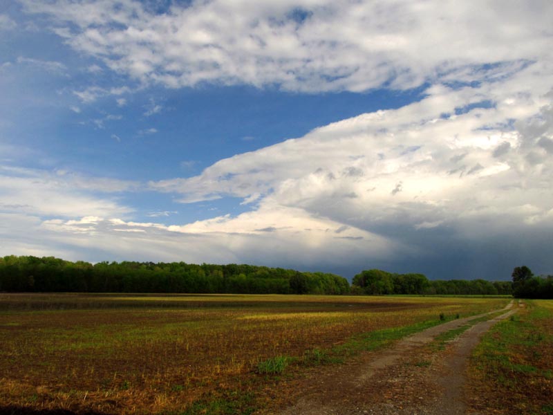
Our camping spot for the night was near Sparta (multiple "THIS IS SPARTA" jokes for the day) at the Bridgestone/Firestone Centennial Wilderness. We set up near the trail-head for the Yellow Bluff Overlook and took a short hike to the bluff before sunset.


Although we didn't realize it at the time, this is how we spent our "Earth Hour" this year- in the dark, around the campfire, miles from a decent cell reception under a half moon that was almost bright enough to read by. Wouldn't have had it any other way.


All the pictures of the day can be found right here.

Saturday, March 24, 2012

March 24, 2012 - Return to Wheeler -or- Hiking in a Thunderstorm

Let me preface this by saying that after the 80% chance of rain for Friday never came to pass, we didn't think anything about a 30% chance of rain on Saturday.


This was a return trip to the same area we hiked on the 4th of this month. The plan was to start further to the west and hike the full outer perimeter of Wheeler Wildlife Refuge to the east, on the far side of I-65.

Chan tries the wood sorrel

Esther also munching on wood sorrel
The hike was going just fine. More wildflowers were out than last time, the sky was full of happy little clouds and we were generally enjoying the day. The kids took turns swinging across the Poison Ivy Ravine of Death on a vine and there was even some wanton skipping.


The first signs were the slightly less happy clouds gathering in the sky.


The second and third signs were these two guys:

Everybody knows that frogs bring the rain

Technically a toad
And then the rain finally did come and we had to turn back just on the other side of the I-65 bridge. We took a short cut back to the bridge and waited out the rain in the shelter of the interstate. Soon enough the sun back out and we were on our way again.


Along the trail we found a body. Not a first for the Refuge...


Chan does what anybody would- poke it with a stick

AAAHHHH ZOMBIE!!!! RUUUUN!!!!

We walked in the sun for about another forty minutes and then the second wave of rain hit us- with bonus lightning and thunder! With no real shelter and a phone-call forecast of more to come, we toughed it out and just walked it for about forty-five minutes in the rain. The sun came back out for the last twenty minutes of the hike- just in time to see the Decatur half in the rain and half out across the river.


Total mileage for the hike: 14.5 miles. Total time: 6 hours, 15 minutes.

Here's all the pictures from the hike and here's the tracklog.

Friday, March 23, 2012

March 23, 2012 - Sportsman Lake and Cullman Wildflower Garden

This Friday we spent in and around Cullman and finished off the list of needed items for future hiking/backpacking trips. After the shopping we stopped at Sportsman Lake Park to take pictures of flowers and stretch our legs on the paved walking trail. Sportsman Lake is one of those spots that I've been going to since I was born. More of a gigantic pond than an actual lake, it's where everybody in Cullman County goes to feed bread to the ducks and the king-size catfish. There's an aging putt-putt golf course that time forgot and a scaled-down train that runs in the summer. One of the newer additions to the park is the paved walking/biking trail that circles the entire lake. It's a little over a mile and a half (according to my tracklog) and was a welcome change to slogging through the wet grass like we used to do when I was a kid. Unfortunately, it looks like the paddle boats are gone for good. Okay, the wife informs me the dock was replaced and they are still in operation.

The Cullman Wildflower Garden is located on the property and Esther and I snapped a few pics.

Taken with artsy-shmartsy phone app
I actually knew the names of a handful of the flowers. Those that I can't remember, I've made up.

African death blossom (or not)

Star anise

Also star anise
Star anise deserves a special mention. You've heard of Tamiflu, yes? Well, you're looking at the natural source of the main ingredient. In fact, you can still get the benefits of taking the medication by using the seeds from the plant. The same ingredient (shikimic acid) is also found in sweetgum and forsythia.

Purple phacelia

Buckeye

Poppy

Klingon death sticker (probably not)

Some kind of honeysuckle

Square flower

A pink spider-wort

Okay, this deserves some mention. All the spider-wort I've ever seen  is a dark, deep purple or at least a faded to dark blue. What would cause this plant to be pink? The truth is a little alarming.


Ooogaaboogaa flower (maybe)

Another kind of honeysuckle - imported


After the walk we grabbed a bite to eat at Backyard Burgers.

This picture was not my idea

All the other pictures can be viewed by clicking RIGHT HERE.
And here's the tracklog of the ramble around the lake.

Saturday, March 10, 2012

March 10, 2012 - Bankhead National Forest: Borden Creek

Today we set out with all three kids in tow to hike along Borden Creek in Bankhead. We started at the trail-head off Bunyan Hill Road and took the trail south right along the creek. GPS reception was less than optimal (SOLAR FLARES!!!) but it looks like we got a nice 3.8 mile trip out of it.


There were flowers in full bloom here that we didn't see yesterday and the waterfalls were just as active.


Zephyr was also along for the trip. She was very helpful by alerting us to the presence of every other dog or dog-shaped object along the trail. As we say, she's braver than she is smart.


And hey, butterflies!


The somewhat wonky tracklog of our hike is here and more pictures of flowers are over here.